
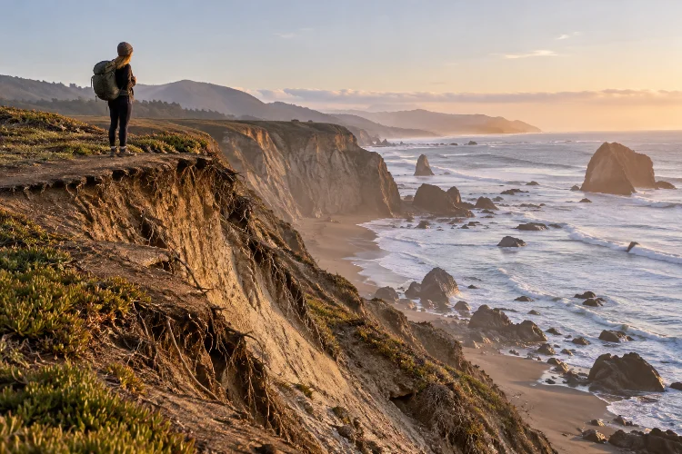
Dramatic coastlines often look permanent. Towering cliffs, sweeping beaches, sea stacks, dunes, and rocky headlands can feel as though they have existed in exactly the same form for thousands of years. In reality, these landscapes are constantly moving.
Waves remove sediment, storms reshape beaches, cliffs retreat, dunes migrate, and landslides can alter familiar trails almost overnight.
Over decades, these processes determine whether a viewpoint remains accessible, whether a beach becomes narrower, and whether roads or walking routes need to be relocated.
Understanding how erosion shapes long-term access to dramatic coastal landscapes therefore matters for much more than geology. It affects tourism, outdoor recreation, infrastructure planning, conservation, and visitor safety.
The U.S. Geological Survey describes coastal erosion as a widespread process capable of causing shoreline retreat, land loss, beach erosion, and infrastructure damage.
For travelers, the important lesson is simple: access to a beautiful coast today does not guarantee the same route will exist decades – or even years – from now.
1. Coastal Landscapes Are Naturally Designed to Change
Erosion is not simply a sign that something has gone wrong. It is one of the processes that creates the spectacular scenery people travel to see.
Breaking waves transfer energy into shorelines, gradually wearing away rock and moving sand and sediment. Over long periods, this can create cliffs, caves, arches, stacks, coves, and other distinctive landforms.
Beaches are equally dynamic. Sand may move along the coast, offshore, or back toward land depending on waves, currents, storms, and sediment supply.
This means a coastal destination should not be viewed as a fixed piece of geography. It is better understood as a continously changing boundary between land and water.
That natural movement becomes particularly important when trails, viewpoints, parking areas, buildings, and roads are constructed close to the shoreline.
2. Cliff Retreat Can Slowly Remove Established Access
Cliff erosion often appears deceptively slow.
A bluff may look unchanged for years before a large section suddenly collapses. USGS researchers note that sea cliffs can remain relatively stable for long periods between landslides that remove significant sections of the bluff top.
For visitor access, that creates an obvious challenge.
A trail constructed several meters from a cliff edge might initially seem comfortably positioned. Years of erosion can gradually reduce that buffer until the route becomes unsafe and must be fenced, redirected, or completely closed.
At Cabrillo National Monument, the National Park Service describes sections of its Coastal Trail as being constantly affected by erosion, with uneven and rugged stairs along parts of the route.
This is why official coastal trails sometimes seem to move inland over time. Relocation is often not unnecessary construction – it is a response to a coastline that refuses to stay still.
3. Beach Erosion Can Change Where Visitors Can Walk
Cliffs are not the only coastal features that retreat.
Sandy beaches can narrow dramatically when erosion removes sediment faster than natural processes replace it. The result may be less recreational space, reduced walking access, and greater exposure of infrastructure behind the beach.
USGS research on California found substantial erosion across portions of the state’s coastline, with 40% of beaches in the study eroding over the long term and 66% showing erosion over the shorter measurement period.
These figures illustrate why yesterday’s wide beach should not automatically be treated as a permanent landscape.
Beach narrowing can also create practical route problems. A coastal walking corridor that once offered plenty of space between cliffs and the ocean may eventually become tide-dependent or disappear at high water.
Where seawalls, roads, or buildings prevent the shoreline from naturally moving inland, beaches may become squeezed into increasingly narrow areas.
4. Major Storms Can Accelerate Years of Gradual Change
Not all coastal erosion happens slowly.
Extreme storms can produce storm surge and powerful waves capable of reshaping beaches, dunes, cliffs, and barrier islands in a very short period.
USGS research identifies beach erosion, dune erosion, overwash, inundation, island breaching, marsh erosion, and cliff erosion among the changes associated with major storms.
For visitors, this explains why an established route can look completely different after one severe weather event.
Stairs may be damaged, dunes can be cut back, paths may collapse, and familiar access points can become unsafe. What appears on an older guidebook or user-generated map may no longer match the actual coastline.
This is particularly relevant after major storms.
Checking current information from land managers before travelling is much more reliable than assuming a trail remains accesible because it existed during a previous visit.
5. Sea-Level Rise Adds Long-Term Pressure
Rising sea levels do not operate separately from coastal erosion. They can increase the exposure of shorelines to waves, flooding, and other processes that contribute to long-term change.
NOAA states that sea level is rising at an increasing rate and notes that sea-level changes influence coastal flooding, shoreline erosion, and storm-related hazards. Local impacts vary because factors such as land movement, currents, and regional conditions differ from place to place.
Research suggests that some coastal cliffs could experience greater retreat as sea levels continue rising.
One USGS modeling study found that erosion rates along parts of Southern California’s coastal cliffs could roughly double under higher sea-level-rise scenarios.
Over decades, this can affect where trails, roads, parking areas, viewpoints, visitor centers, and other infrastructure can realistically remain.
Long-term coastal access is therefore partly an adaptation problem.
6. Trails and Infrastructure May Need to Move Inland
When erosion approaches human infrastructure, managers face difficult choices.
One option is to defend the shoreline through structures such as seawalls or other forms of coastal engineering. Another is to relocate vulnerable infrastructure farther inland where space and environmental conditions allow.
Neither option is simple.
The National Park Service notes that coastal hazards threaten natural and cultural resources, infrastructure, and public recreational opportunities, requiring managers to consider adaptation and hazard preparedness.
Moving a trail inland may preserve public access, but the new route could cross sensitive vegetation, archaeological sites, steep terrain, or private property.
Protecting a road with hard structures can also alter how sediment moves along the coastline.
Good long-term managment therefore has to balance access, ecosystem protection, safety, cost, and the natural movement of the shoreline.
7. Losing Beaches Can Change the Character of a Destination
Coastal erosion does not always mean that an entire destination disappears.
Instead, the experience may gradually change.
A broad recreational beach might become a narrow strip accessible mainly at low tide. A cliff viewpoint may move farther inland. A famous coastal walk could require a detour that removes direct access to the shoreline.
In some locations, the change could be much larger.
USGS modeling has explored scenarios in which significant portions of Southern California beaches could become completely eroded against existing infrastructure or sea cliffs under substantial future sea-level rise.
More recent USGS-supported research on Oʻahu has also projected substantial potential losses of sandy shoreline during this century under continuing erosion and sea-level rise.
These are projections rather than guarantees, but they show why tourism planning needs to consider decades rather than individual seasons.
8. Erosion Can Also Create New Landscapes
Coastal change is not purely about loss.
The same erosion that removes a cliff edge may expose new rock formations. Collapsing sections can produce new coves, while sediment movement can create or enlarge beaches elsewhere.
Coastlines naturally combine erosion and deposition. Material removed from one location may eventually become part of another beach, sandbar, dune, or coastal feature. The NPS describes coastal environments as dynamic systems shaped by waves, tides, currents, erosion, and deposition.
For visitors, this means familiar scenery can evolve into something new.
However, newly created features are not automatically safe. Fresh landslides, unstable cliff faces, recently deposited sediment, and changing channels can remain hazardous for some time.
Curiosity about a changed landscape should always be balanced with current safety restrictions.
9. Historical Shoreline Data Helps Predict Future Access
Long-term erosion becomes easier to understand when coastlines are measured over decades.
Scientists compare historical maps, aerial photographs, lidar data, elevation models, and modern shoreline measurements to calculate rates of change.
In 2026, USGS released a national compilation combining previously published shoreline-change rates for the contiguous United States, using historical shoreline positions extending from the 1800s through the 2010s.
The data helps identify areas particularly susceptible to erosion or accretion.
This kind of information is valuable for more than science.
Coastal managers can use long-term trends when deciding where future trails should go, how far infrastructure should sit from eroding cliffs, and which locations may require new access strategies.
Visitors rarely see this planning work, but it can determine whether public access remains possible decades into the future.
10. Responsible Visitors Can Help Reduce Additional Damage
Natural erosion cannot be stopped by careful hiking, but human behavior can make fragile coastal areas deteriorate faster.
Walking off established trails can destroy vegetation whose roots help stabilize soils. Creating shortcuts down cliffs can encourage drainage channels and increase surface erosion. Crowding near unstable edges can also create unnecessary safety problems.
When a trail is redirected or closed, visitors should follow the official route rather than attempting to recreate the old path.
Erosion may have already weakened the ground beyond what is visible from above.
Respecting barriers, avoiding fragile slopes, checking current alerts, and using established access points help land managers preserve recreational access for longer.
The objective is not to freeze the coastline in place. That is impossible. It is to avoid adding preventable damage to a landscape already changing through natural processes.
Coastal erosion does much more than reshape scenery. Over years and decades, it can narrow beaches, move cliff edges, damage trails, threaten infrastructure, and completely change how people reach dramatic natural destinations.
Understanding how erosion shapes long-term access to dramatic coastal landscapes helps travelers appreciate why coastal trails are relocated, viewpoints close, and familiar beaches sometimes look different from one visit to the next.
Before visiting an erosion-prone coastline, check current trail conditions and respect closures or reroutes. For planners and conservation managers, long-term shoreline monitoring is equally important when deciding where future access should be built.
Coastlines will always change; the real challenge is adapting recreational access without destroying the natural processes that make these places spectacular.